The North Atlantic Hurricane seasons spans from June to November with late August through September usually being the most intense period of the hurricane season.
While news reports focus on a hurricane's wind speed, the real indication of a hurricane's power lies in its pressure.
The lower the pressure, the more powerful (and more destructive) the hurricane.
Also, the faster the pressure drops, the more intense the hurricane.
We're used to higher numbers indicating higher power or strength (like a higher number of knots, miles, or kilometers measured means a stronger hurricane).
High pressure sounds stressful while low pressure sounds relaxed.
But in weather, pressure works exactly the opposite: A lower number means more strength—more intensified pressure—and hence, more destruction.
For example, during the horrifically destructive Labor Day hurricane of 1935 (before hurricanes started receiving names), people with barometric pressure-readers noticed the pressure visibly plummeting before the hurricane hit.
Ultimately, it reached the unusual low of 892 millibars ("mb").
Here is a chart of how they categorize hurricanes:
Category 1: Minimal — Greater than 980 mb or 28.94 in; 119–153 km/h 74–95 mph
Category 2: Moderate — 965 to 979 mb or 28.50 to 28.91 in; 154–177 km/h 96–110 mph
Category 3: Extensive — 945 to 964 mb or 27.91 to 28.47 in; 178–208 km/h 111–129 mph
Category 4: Extreme — 920 to 944 mb or 27.17 to 27.88 in; 209–251 km/h 130–156 mph
Category 5: Terrible — Less than 919 mb, 27.17 in.; more than 252 km/h 157 mph
If barometric pressure lowers by more than 6 millibars in less than 3 hours, the hurricane is considered as "rapidly intensifying."
If it remains the same or lowers by less than 6 millibars, it's considered "holding steady."
You know all those hurricanes predicted to turn monstrous over the past couple years and then didn't?
Well, generally, the best indication lay in their pressure reading.
(Remember: The news focuses on windspeed, which is only the secondary indicator of hurricane force—again, don't disregard windspeed altogether, but look at it within the context of the accompanying pressure.)
For example, a hurricane with a windspeed of, say, 135 mph (low Category 4) and pressure measured at 957 mb (well within Category 3) that also holds steady, will have newscasters hyperventilating about a Category 4 hurricane on the way, with all sorts of terrible predictions.
But that generally won't prove true.
Now, I'm not saying a Category 3 hurricane is something to hang around for or that we should just ignore windspeed, but it was clear from the beginning (by the pressure reading) that it was unlikely to be a real Category 4 hurricane.
And indeed, it generally wasn't.
Sure, it's good to prepare for a Category 3 by treating it like a Category 4.
But so many overhyped warnings cause people to take hurricane forecasts less seriously, which ends up endangering people when they need to take a hurricane forecast seriously—but don't.
Forecast hurricanes yourself by focusing on the pressure.
For example, Hurricane Nora in the Eastern Pacific:
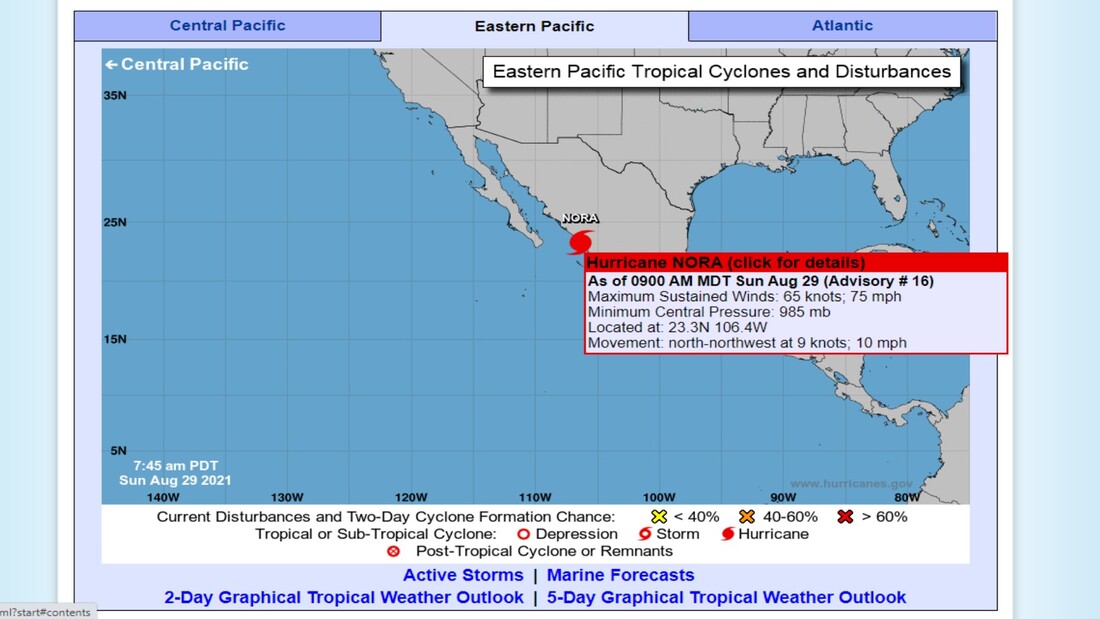
When I checked this a few hours ago, the pressure was the same as now.
Maybe the winds slowed down a bit. I think earlier, the windspeed hit 80mph as opposed to the current 75mph.
But the pressure remains exactly the same.
Hurricane Nora remains a Category 1 hurricane and not a particularly awful one (though people in that area should take responsible precautions).
(Update 90 minutes later: Nora has been downgraded to a Tropical Storm as her windspeed slowed to 70 mph and her pressure weakened from 985mb to 988mb. Again, this was predictable based on her relatively weak pressure & lack of intensification of that same pressure; it held steady for hours.)
Hurricane Ida, however, is more of a concern.
When I checked a few hours ago (late morning, early afternoon), Hurricane Ida's windspeed reached 140mph, but her pressure lay around 948 mb.
As you can see from the chart above, Hurricane Ida's windspeed indicated an average Category 4, but her pressure indicated a strong Category 3.
She was labeled as a Category 4, which makes sense when the pressure-reading remains in Category 3 by only 3 millibars.
But now, Hurricane Ida's pressure plummeted to 933 millibars & her windspeed increased to 150mph:
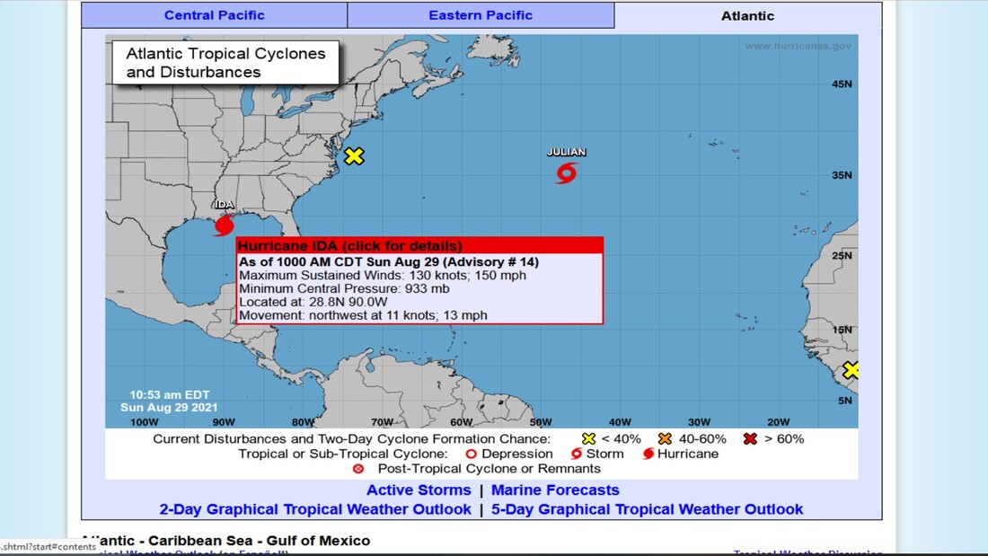
The windspeed now places Hurricane Ida as a strong Category 4 (4's top windspeed is 156mph).
But the 10mph increase in windspeed isn't the big deal here.
Hurricane Ida's current pressure-reading of 933 millibars not only places her squarely in Category 4, it also shows a massive pressure drop of 15 millibars within only a few hours.
That pressure-drop indicates a rapidly intensifying hurricane in addition to a powerful one.
(Update 90 minutes later: Hurricane Ida's pressure dropped another 3 millibars to 930 mb since I last checked 90 minutes ago. Despite her windspeed & traveling time remaining the same, the drop in pressure indicates an intensifying hurricane, which was predictable by noting the previous drop in pressure by 15 mb AND the rapidity of the drop in pressure within a few hours.)
This means that people in the hurricane's projected path (which is subject to change if winds change direction) need to fortify their homes & possibly evacuate, depending where they are in the path.
People outside the direct path also need to keep tabs on what's happening, both because the weather affects them outside that path & because the winds can suddenly change direction.
It also looks like the hurricane's traveling speed slowed down from 15mph to 13mph, but not sure if that's significant.
If a powerful hurricane travels slowly, it increases the damage because rather than passing through rapidly, it takes its time & just grinds there for a while.
I don't know why the news focuses almost exclusively on windspeed. Maybe because people instinctively understand that better than discussions of pressure & millibars?
Not sure.
You can keep track of North American hurricanes here:
https://www.nhc.noaa.gov/
So remember:
(In other words, the LOWER the number of millibars the MORE POWERFUL the hurricane.)
In the future, you can understand better how to respond to hurricane warnings by keeping an eye on the pressure.
Don't automatically dismiss the hype, but don't get overwrought either.
Always check the pressure.
But the 10mph increase in windspeed isn't the big deal here.
Hurricane Ida's current pressure-reading of 933 millibars not only places her squarely in Category 4, it also shows a massive pressure drop of 15 millibars within only a few hours.
That pressure-drop indicates a rapidly intensifying hurricane in addition to a powerful one.
(Update 90 minutes later: Hurricane Ida's pressure dropped another 3 millibars to 930 mb since I last checked 90 minutes ago. Despite her windspeed & traveling time remaining the same, the drop in pressure indicates an intensifying hurricane, which was predictable by noting the previous drop in pressure by 15 mb AND the rapidity of the drop in pressure within a few hours.)
This means that people in the hurricane's projected path (which is subject to change if winds change direction) need to fortify their homes & possibly evacuate, depending where they are in the path.
People outside the direct path also need to keep tabs on what's happening, both because the weather affects them outside that path & because the winds can suddenly change direction.
It also looks like the hurricane's traveling speed slowed down from 15mph to 13mph, but not sure if that's significant.
If a powerful hurricane travels slowly, it increases the damage because rather than passing through rapidly, it takes its time & just grinds there for a while.
I don't know why the news focuses almost exclusively on windspeed. Maybe because people instinctively understand that better than discussions of pressure & millibars?
Not sure.
You can keep track of North American hurricanes here:
https://www.nhc.noaa.gov/
So remember:
- Lower pressure → Stronger hurricane
- Rapidly lowering pressure → Rapidly intensifying hurricane
(In other words, the LOWER the number of millibars the MORE POWERFUL the hurricane.)
In the future, you can understand better how to respond to hurricane warnings by keeping an eye on the pressure.
Don't automatically dismiss the hype, but don't get overwrought either.
Always check the pressure.


 RSS Feed
